David J Grenier - Fine Art Photography
Fine Art Photography
_24A8061-Edit.jpg

Blog

David J Grenier Fine Art Photography Blog Pages

Posts in Blog
Chasing Sunsets, July 2013

Recently, I have found myself chasing sunsets around and in the area where I am fortunate to live, El Dorado Hills, in the California's Sierra Nevada foothills. Having lived in this area for the past ten years, I have developed some local knowledge as to where the best locations could be for a sunset on any given night, some a ten minute drive, stretching all the way up to South Lake Tahoe's beautiful Emerald Bay, a ninety minute drive each way. I love sunsets because they can be so colorful, with the setting sun’s ability to brightly light up any clouds in the sky with colors that are simply magical to witness and photograph. The most colorful moments are the few minutes before the precise sunset time, and the few minutes after the sun has gone down below the horizon. As a photographer, Mother Nature typically gives you less than ten minutes to capture these colors at their brightest and most vivid, which requires you to be in place and ready to shoot. This includes predetermining the best composition, depth of field, focus, metering/exposure, ISO, etc., and be fully aware of the changing light conditions and respond appropriately. It is exciting sometimes simply trying to keep up, especially when you are also in awe of what Mother Nature is providing for that particular evening's 'show' right before your very own eyes! The excitement is in the thrill to be creative now and in the moment, with the need to respond and capture a scene that does not last long and you most likely will never see again!

The following three images were all captured in this month of July, 2013, generally not know as a great month for clouds and beautiful sunsets in the local area, but ones that I am happy to have been there to witness, enjoy and capture.

IMG_6320-Edit-2-700x466.jpg

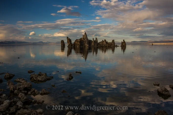
'Lake on Fire", Emerald Bay, South Lake Tahoe, California, 8:31 pm, July 10, 2013, Canon 5D Mk III; Canon EF16-35mm f/2.8L lens @ 18mm; 0.3 sec @ f/11; ISO 100

This image  began with me noticing the gathering cloud patterns in the afternoon near my home. A short debate in my mind as to what would be the best location to go to for the evening's sunset was ended by an on the spur of the moment decision to drive up to Emerald Bay, in South Lake Tahoe. I had been to this particular location numerous times previously, with varying degrees of success with a sunset, and just had a hunch that 'tonight could be good'. I have learned not to build up my expectations on 'what could be' on any given occasion and instead accept and respond to 'what you are given'.

Sunset was officially at 8:30 pm and I arrived at 7:45 pm only to notice a gathering of about twelve people right at my favorite and most effective spot for a sunset shoot at Emerald Bay. I looked for an alternate spot, none of which I liked, and waited patiently for what turned out to be a wedding ceremony to conclude and the all the participants to depart. I quickly got into position about 24 inches above the ground, with beautiful boulders forming an effective and interesting foreground and simply waited for the magical light show to begin.

The image above was captured one minute after the official sunset time, with the best light and color being available for no more than five minutes. The sight of the 'lake being on fire' with an incredible red/orange glow reflected on the water, made me utter OMG several times in sheer delight. I left feeling exhilarated to have made the right decision to make the ninety minute drive up to the Sierras and be rewarded beyond my wildest expectations with the best sunset I had ever seen at Emerald Bay!

IMG_6458-Edit-Edit-700x463.jpg

'Country Roads'. El Dorado Hills, California, 8:23 pm, July 24, 2013, Canon 5D Mk III; Canon EF16-35mm f/2.8L lens @ 16mm; 0.5 sec @ f/11; ISO 100

This image was captured at a location about a ten minute drive from my home. I chose this location by driving around and looking at the position of the clouds in the sky and contemplating and predicting what the light may produce, and where, with the setting sun. I also always looking for an interesting foreground and the road, that leads a viewer’s eye into the shot, with the gate and fence materials turned out to be well suited for the patterns generated in the sky by the clouds.

IMG_6479-Edit-Edit-700x466.jpg

'Life's Twists and Turns', American River, Salmon Falls Road, California, 8:21 pm, July 25, 2013, Canon 5D Mk III; Canon EF16-35mm L lens @ 16mm; 0.5 sec @ f/11; ISO 100

The final image I have here was of the sunset that occurred the day after the image shown above. Again, the location was determined by the position of the clouds in the sky and my prediction of the reflected light and colors of the setting sun. This night, I was simply winging it as I had never been to this particular spot for a sunset shoot, and had not been here in about five years. Arriving a little later than ideal I had about five minutes to walk down a fairly steep trail, pick a spot, set up my tripod and camera and begin to trigger the shutter. What helped me make a quick decision was the reflection of the clouds I saw in a little cove of the river, as well as the layers of the bank on the left hand side. This time as well I set up close to the ground, chose a composition that I thought would work well and pulled the trigger sitting on my butt on damp ground! As it turned out, this was the first image I captured that night and the best!

I would like to end this blog post with a quote from a great man, who I admired greatly and was influenced by when I was a child growing up in Sri Lanka.

'When I admire the wonders of a sunset or the beauty of the moon, my soul expands in the worship of the creator'. ~ Mahatma Gandhi

Adventureland, aka Yosemite National Park, May 2013

Mark Twain is said to have remarked that Yosemite was so incomparable that it had to be the place God cast all his remaining treasures after the creation of the world! I am fortunate to live four hours away from Yosemite National Park, which I fondly refer to as Adventureland, as it is always an adventure for me to visit this huge and wondrous place in Northern California that I have lovingly gotten to know over the last few years. I first visited Yosemite some 25 years ago, on a family camping adventure with my young daughter and son. I have only vague memories of that visit, but the one lasting memory I have is of my young daughter, upon her return home, telling her friends that she had just visited 'Mysemite'!

As a photographer, using a newly purchased DSLR camera, I visited Yosemite again in 2010, and the adventure began and continues to this day. I last visited Yosemite on May 17, for an impromptu overnight visit. I typically stay away from the Park in summer because of the huge crowds that flock to this magnificent  National Park, but was driven there at this time of the year by the need for 'another adventure' and a weather forecast that promised 'clouds in the sky'. The images in this blog are from of my last visit, and yes, it was seasonally crowded with long lines of vehicles to get in to the Park, and congestion in the heavily trafficked areas of Yosemite Valley. About 4,000,000 people visit Yosemite annually, and it would be my guess that well over 3,000,000 of those visitors arrive during the months of April through October.

It has become a routine for me to drive to Tunnel View first when arriving into Yosemite, because I have learned from experience that this is a great vantage point to see what's happening weather wise in the whole Valley, and the image below is what greeted me on the morning of May 17, 2013.

IMG_4362-Edit1-700x466.jpg

Tunnel View

A quote from the the Yosemite National Park website http://www.nps.gov/yose/index.htm ~ "Not just a great valley, but a shrine to humanforesight, the strength of granite, the power of glaciers, the persistence of life, and the tranquility of the High Sierra. First protected in 1864, Yosemite National Park is best known for its waterfalls, but within its nearly 1,200 square miles, you can find deep valleys, grand meadows, ancient giant sequoias, a vast wilderness area, and much more."

The National Park Service was created by an Act signed by President Woodrow Wilson on August 25, 1916. Yellowstone National Park was established by an Act signed by President Ulysses S. Grant on March 1, 1872, as the nation's first national park.

The national park system comprises 401 areas covering more than 84 million acres in every state (except Delaware), the District of Columbia, American Samoa, Guam, Puerto Rico, and the Virgin Islands. These areas include national parks, monuments, battlefields, military parks, historical parks, historic sites, lakeshores, seashores, recreation areas, scenic rivers and trails, and the White House.

Total recreation visitors to all National Parks in 2011 was an astounding 278,939,216 people!

IMG_4418-700x466.jpg

El Capitan

El Capitan is a vertical rock formation in Yosemite National Park, located on the north side of Yosemite Valley, near its western end. The granite monolith extends about 3,000 feet (900 m) from base to summit along its tallest face, and is one of the world's favorite challenges for rock climbers. The formation was named "El Capitan" by the Mariposa Battalion when it explored the valley in 1851. El Capitán ("the captain", "the chief") was taken to be a loose Spanish translation of the local Native American name for the cliff, variously transcribed as "To-to-kon oo-lah" or "To-tock-ah-noo-lah" .

IMG_4407-700x466.jpg

The Three Brother

The Three Brothers, 7,783 ft (2,372 m),  is a rock formation located just east of El Capitan and consists of Eagle Peak (the uppermost "brother"), and Middle and Lower Brothers. John Muir considered the view from Eagle Peak to be the most beautiful view of Yosemite Valley available. John Muir (21 April 1838 – 24 December 1914) was a Scottish-born American naturalist, author, and early advocate of preservation of wilderness in the United States. His activism helped to preserve the Yosemite Valley, Sequoia National Park and other wilderness areas. The Sierra Club, which he co-founded on May 28, 1892 in San Francisco, is now one of the most important conservation organizations in the United States.

IMG_4525-700x466.jpg

Gates of the Valley

One of the two major waterways in the park is the Merced River, which carries rainwater and snow melt from the high Sierras and drains the southern part of the park. Arising high in the Sierra backcountry in the park, if flows though the heart of Yosemite Valley. The picture babove shows the river from the location known as "Gates of the Valley" or "Valley View", and in the background can be seen El Capitan (left) and Cathedral Rocks and Bridalveil Falls (right).

IMG_4573-700x466.jpg

'As The World Turns'

The final image I leave you with is the star trails above Yosemite Falls. Captured at 9:58 pm on May 17, this was a 35 minute exposure that shows the movement of stars in the that time frame, with the exception of the constant North Star, the little white dot shown just above the falls.

Yosemite Falls is the highest measured waterfall in North America, and it is a major attraction in the park, especially in late spring when the water flow is at its peak. The total 2,425 feet (739 m) from the top of the upper falls to the base of the lower falls qualifies Yosemite Falls as the sixth highest waterfall in the world.

I would like to end this blog with a quote from John Muir, taken from his book The Yosemite, Copyright 1912, by the Century Co .

'Everybody needs beauty as well as bread, places to play in and pray in, where nature may heal and give strength to body and soul alike.'

The Yosemite by John Muir - book cover first edition

May you enjoy a visit to Yosemite National Park someday to marvel at 'the place God cast all his remaining treasures after the creation of the world'!

I dedicate this blog today to my daughter Michelle Grenier on her birthday - Happy Birthday Michelle, Love, Dad!

Adventures in Arizona, May 2013

I just returned from spending seven enjoyable days in Arizona, covering a multitude of activities that have both touched my heart and satisfied the artist that resides within me. It all began with spending four days in Winslow, where I participated in a food run with the ‘Adopt-A-Native-Elder Program'.

Adopt-A-Native-Elder Porgram

Here is a direct quote from their website – ‘The Adopt-A-Native-Elder Program exists to create a Bridge of Hope between Native Americans and other cultures. It allows us to reach out to one another, share our gifts, and mend the broken circle of our relationship with the Land and the Native Americans who hold it in sacred trust. The Program provides food, simple medicines, clothing, fabric, and yarns to help these Elders live on the Land in their traditional lifestyle. As they have become elderly, it has become more difficult for them to support themselves on the Land in their traditional ways.’

I was deeply touched by this Program that has been operating for over 27 years. I found it to be a profound experience and one that I intend to attend as often as possible. ‘Respect your elders’ was a phrase that was repeated to me many times by my parents when I was a child, a concept that I struggled with in my rebellious youth. It appears that I now have reached a point in my life where I desire to give something back to all those ‘elders’ that have touched my own life in profound ways, and this program is a perfect vehicle to fulfill some of these desires.

The gratitude that I witnessed in the eyes of the Navajo Elders I was fortunate to come in contact with was priceless, and I would like to encourage you to look further into this Program at their website www.anelder.org

IMG_0969-700x525.jpg

The above is a a photograph of the food run line-up that I captured with my iPhone  just after we had set up the line for distribution to the Elders at the Big Mountain reservation.  I am posting this image with permission given to me by the Adopt-A-Native-Elder Program.

Red Rocks of Sedona

I then traveled to Sedona, with the friend who so kindly invited me participate with her in the above Program. Sedona's main attraction is its array of red sandstone formations, the Red Rocks of Sedona. The formations appear to glow in brilliant orange and red when illuminated by the rising or setting sun. I had previously visited Sedona in January, 2011, at the invitation of friends that I knew from the Bay Area, and was immediately struck by the sheer beauty of the magnificent red rock structures so prominent in this area. However, since it was the middle of winter the area was devoid of the brilliant greenery that I was treated to during this visit, which adds a whole new dimension to these unique structures.  Below are some of my favorite red rock formations captured over the two days spent in Sedona.

IMG_4179-2-700x466.jpg

Cathedral Rock

Cathedral Rock at Red Rock Crossing is one of my favorites in Sedona, and is one of the most-photographed sites in Arizona. Early summer is a beautiful time of the year to photograph this site as the greens and reds are present in all their glory.

IMG_4132-2-700x466.jpg

Cathedral Rock in the background, with the old mill and water wheel at the Crescent Moon Ranch recreation area in the foreground

IMG_4142-Edit-2-700x466.jpg

Cathedral Rock captured from Oak Creek that runs through Crescent Moon Ranch

IMG_4085-2-700x466.jpg

Courthouse Butte, located next to Bell Rock, is also a heavy photographed site in Sedona

IMG_4093-2-700x466.jpg

The beautiful Bell Rock

The Chapel of the Holy Cross, a  unique Roman Catholic chapel, is built into this magnificent red rock (below) just outside Sedona

IMG_4286-Edit-21-700x466.jpg

Garland's Oak Creek Lodge

IMG_4335-700x466.jpg

The entry way to Garland's Oak Creek Lodge

IMG_4222-2-700x466.jpg

Oak Creek Canyon

We were fortunate to spend two nights at the magnificent Garland's Oak Creek Lodge, in the beautiful Oak Creek Canyon, just outside Sedona. Highlights from their website -  'Garland's Lodge provides a unique experience in an unforgettable setting, marrying the beauty of Sedona's red rocks with the ever-changing seasons of Oak Creek Canyon. Sixteen cozy cabins nestle on ten lush acres of organic gardens and apple orchards.

The original homestead building dates back to the early 1900's and still functions as the Lodge kitchen. Garland's Lodge is much more than just another Sedona bed and breakfast or B&B. Afternoon tea, and sumptuous dinners and breakfasts are served in the historic main lodge, and are included in your stay, with seasonal menus from our award-winning cookbook, "Sharing the Table at Garland's Lodge".'

Check it out in more detail at http://www.garlandslodge.com/

Enjoy!

'Flowers are the Earth's Way of Laughing', April 2013 (revised April 2023)

Spring and "springtime" refer to the season, and also to ideas of rebirth, rejuvenation, renewal, resurrection, and regrowth.

Spring is also the ‘season of hope’, and the time when trees begin to 'green' and flowers remind me that Mother Nature is truly amazing and profoundly inspiring to me as a photographer.

The flowers of spring also brings to mind one of my favorite quotes, ‘Flowers are the Earth’s way of laughing’, a quote attributed to the America poet, essayist, and lecturer, Ralph Waldo Emerson (1803-1882).

And one more new quote – “Flowers always make people better, happier and more helpful; they are sunshine, food and medicine for the soul.” – Luther Burbank

The images below are my tribute to spring, using mostly flowers from my backyard, and inspired by the sound of the Earth laughing!

Enjoy!

(Updated April 2023.) This has been one of my all-time most read blog posts. Written and posted originally in April 2013, I have updated it some ten years later with some of my all-time favorite flower images.

Give and Take, February 2013
IMG_1796-2-700x466.jpg

'Three Leaves'

I92C1353-2-700x466.jpg

'Gold 'N Ice'

I92C1405-546x900.jpg

Horsetail Falls, Northside Drive location, February 14, 2013

I92C1499-21-545x900.jpg

Horsetail Falls, Southside Drive location, February 15, 2013

As most of my friends already know, I experienced a stressful and traumatic event at the end of last year. On December 20th, five days before Christmas, my vehicle was robbed in a parking lot in Anaheim Hills, Southern California. I had seventy four items taken out of my vehicle, with a total replacement value of over $17,000. I was left with a feeling of disbelief, shock, violation and anger. All of the photographic equipment that I had carefully and painstakingly collected over many years was taken, along with my complete set of golf clubs, golf shoes, etc.. Also taken, an iPod, a gym bag with goggles, flippers, ear plugs, etc., the keys to my security gate, a Fastrack transponder, etc. etc.

Now just over two months later, I have replaced my photographic equipment and feel that, somehow someway, this occurred to me so that I would end up with better equipment than what I had; better equipment that I have wanted for some time but could never bring myself to buy. In retrospect, it is not clear to me why I prevented myself from getting the camera equipment that I wanted, and I am appropriately reminded of the phrase, “When life gives you lemons, make lemonade”.

Recently, I got back from my first photo shoot with this new equipment, a few days in Yosemite National Park, where the initial objective was to shoot the yearly occurrence that happens during the last two weeks of February, Horsetails Falls lighting up and giving the appearance that it is on fire. If Horsetail Fall is flowing and the weather conditions are just right, the setting sun illuminates the waterfall, making it glow orange and red, as can be seen in the two images of Horsetail Falls that I captured on February 14 & 15, 2013.

I have also posted a couple of other images from that shoot that can be described as ‘abstracts in nature’.  I am finding these tighter images more fun and satisfying to capture these days, particularly when the larger landscape opportunities are more mundane or uninspiring due to the weather conditions particular for that day or season. These abstracts, for me, tend to be more creative, unique and expressive when I get to design something from nothing, from whence I live up to my own term ~ 'LiquidDesigns'.

diVittorio Winery Tasting Room Gallery, January 2013
P1010995-1-700x525.jpg

I am pleased to announce that some of my photography is on display at the diVittorio Winery Tasting Room in Camino, California. I have very generously been given permission, by the owner's of the Winery, to set up a small gallery of my images, so that visitors will be able to view and purchase matted prints of a selection of my work.

The diVittorio Winery Tasting Room is located at - 3500 Carson Road, Camino, California. Their phone number is 530-621-2166. Their website is http://divittoriowinery.com/  They have a wonderful selection of red wines and award winning ports that are well worthwhile stopping by to sample at their spacious tasting room, Wednesdays through Mondays, and to view and/or purchase my photography in person. Looking forward to your visit sometime soon!

P1010988-1-700x525.jpg
Native American Portraits, January, 2013
I92C0950-1-2-700x466.jpg
I92C1092-1-2-600x900.jpg
I92C1095-1-3-2-600x900.jpg

It was an honor and my pleasure to recently participate in an Arizona Highways Magazine photo workshop at The Heard Museum of Native Cultures and Art, Phoenix, Arizona. It was my first experience working with Navajo people in a photo shoot setting and my initial exposure to their colorful and detailed ceremonial dress.

It was an experience that I enjoyed a great deal and would like to spend more time pursuing further. As a traditional, mostly landscape photographer, venturing into the work of portraits is something that I have wanted to do for sometime now. I could not be more thrilled and motivated to continue this activity after attending this workshop.

Enjoy!

Zion National Park, November 2012
IMGL4185-1-2-700x456.jpg
IMGL4337-1-2-700x466.jpg
IMGL4144-1-2-700x466.jpg

After visiting Bryce National Park at the end of October, 2012, on the way back I had the good fortune of visiting the magnificent  Zion National Park for a couple of days as well.

A prominent feature of the 229-square-mile (590 km2) park is Zion Canyon, which is 15 miles (24 km) long and up to half a mile (800 m) deep, cut through the reddish and tan-colored Navajo Sandstone by the North Fork of the Virgin River. Located at the junction of the Colorado Plateau, Great Basin, and Mojave Desert regions, the park's unique geography and variety of life zones allow for unusual plant and animal diversity. Zion National Park includes mountains, canyons, buttes, mesas, monoliths, rivers, slot canyons, and natural arches.

Human habitation of the area started about 8,000 years ago with small family groups of Native Americans. Mormons came into the area in 1858 and settled there in the early 1860s. In 1909, U.S. President William Howard Taft named the area a National Monument to protect the canyon, under the name of Mukuntuweap National Monument. In 1918, however, the acting director of the newly created National Park Service changed the park's name to Zion. According to historian Hal Rothman, "The name change played to a prevalent bias of the time. Many believed that Spanish and Indian names would deter visitors who, if they could not pronounce the name of a place, might not bother to visit it. The new name, Zion, had greater appeal to an ethnocentric audience."

IMGL4455-1-2-600x900.jpg
IMGL4468-1-2-700x466.jpg
IMGL4566-1-2-700x466.jpg

The Narrows in Zion National Park, is a section of canyon on the North Fork of the Virgin River, that is a longest slot canyon in the USA. The hike of The Narrows is one of the premier hikes on the Colorado Plateau. The term The Narrows refers to both the through-hike of The Narrows, and to The Narrows themselves, especially the 3.6 miles (5.8 km) long section of canyon between the end of the Riverside Walk Trail and Big Spring.

Hiking The Narrows was the highlight of this trip. We managed to complete the hike, through waters up to our knees at times, in just under 7 hours. It was a particularly arduous task for me as I had the physical handicap of having blisters on both my feet from hiking Bryce Canyon for a couple of days, and had fallen and badly scraped both my knees on a night photo shoot the day before. It was still a memorable experience and accomplishment, and resulted in the images above.

Enjoy!

Bryce Canyon National Park, November, 2012
IMG_0864-11-700x524.jpg
IMGL3741-1-700x466.jpg
IMGL3923-12-700x466.jpg

I visited Bryce Canyon at the end of October, 2012. I was astounded to see this magnificent site the first time I laid my eyes on the hoodoos that make up this unique canyon.

Bryce Canyon National Park is located in southwestern Utah about 50 miles (80 km) northeast of and 1,000 feet (300 m) higher than Zion National Park.  The rim at Bryce varies from 8,000 to 9,000 feet (2,400 to 2,700 m). The major feature of the park is Bryce Canyon, which despite its name, is not a canyon but a collection of giant natural amphitheaters. Bryce is distinctive due to geological structures called hoodoos, formed by frost weathering and stream erosion of the river and lake bed sedimentary rocks. The red, orange, and white colors of the rocks provide spectacular views for park visitors.

Bryce Canyon area was settled by Mormon pioneers in the 1850's and was named after Ebenezer Bryce, who homesteaded in the area in 1874. The area around Bryce Canyon became a National Monument in 1923 and was designated as a National Park in 1928. The park covers 35,835 acres (55.99 sq. miles; 145.02 sq. km) and receives relatively few visitors compared to Zion National Park and the Grand Canyon, largely due to its remote location.

What caught my eye at Bryce are the hundreds of bright colored hoodoos, which in sunny afternoon light appear to glow and have an iridescent quality to them. As the sun moves over the various amphitheaters from sunrise to sunset, the colors of the hoodoos change and create a never ending pallet of colors that are magnificent and simply delightful to watch.

The first image above was taken with my iPhone. Upon arrival in the afternoon, I walked to the canyon having made the decision that we did not need to take our camera gear with us, as we were 'just going up there to see Bryce for the first time and get oriented'. I never saw these same colors and iridescence again, but did capture the sunrise and the sunset images also shown above with my 'big boy' camera equipment.

Mono Lake, An Ancient Sea - Part II
IMGL3073-700x466.jpg

'Kiss The Sky'

IMGL3099-700x466.jpg

'Shipwreck In Paradise'

IMGL3121-700x466.jpg

'Mono Lake Sunset'

I wanted to post a few images from my recent photo shoot to Mono Lake and also write some more about this amazing place. I will do that by continuing to quote from the California State Parks brochure that I bought at the South Tufa Area.

To begin with I wanted to mention how grateful I was for the beautiful skies that we enjoyed during our visit. Clouds make such a difference to a landscape photographer in that they provide that additional element to a photograph that adds color, interest and simply makes an image all that more aesthetic. In meteorology, a cloud is a visible mass of liquid droplets or frozen crystals made of water or various chemicals suspended in the atmosphere above the surface of a planetary body. The international cloud classification system is based on the fact clouds can show free-convective upward growth like cumulus, appear in non-convective layered sheets such as stratus, or take the form of thin fibrous wisps, as in the case of cirrus.

A major conservation effort to save Mono Lake was waged for many years, and I am sure that at some point somewhere in California you would have seen a ‘Save Mono Lake’ bumper sticker. To quote from the State Parks brochure: “In 1941, the City of Los Angeles began diverting streams that feed Mono Lake. The diversion of those streams caused Mono Lake to drop more than 40 feet, exposing about 17,000 acres of ‘recession’ lands. Recession lands are the exposed lakebed lands below the elevation of 6,417 feet above sea level, where the lake surface was in 1941 before diversions began. Concerns were raised about the lake’s ecosystem, the effects of wind-blown alkali dust on Mono Basin air quality, and the aesthetics of a shrinking lake. Citizens groups – The Mono Lake Committee and the National Audubon Society – began legal efforts to protect Mono Lake.

On September 28, 1994, after 16 years of court battles, research and hearings, the State Water Resources Control Board issued an order to protect Mono Lake and its tributary streams. The effects of the order will ultimately raise the level by 17 feet to an elevation of 6,392 feet above sea level over the next 15-20 years. All parties involved agreed to accept this plan and implement it in a spirit of cooperation.

While the lake may be saved on paper, much remains to be done. Stream and waterfall habitat restoration effort are still underway, with input from the U.S. Forest Service and Reserve staff and the Mono Lake Committee. The question today is not whether Mono Lake will be saved, but how it will be saved.”

We the People, on occasion are still heard and can effect change when we come together for a worthwhile cause!

Enjoy..........