Fine Art Photography
_24A8061-Edit.jpg

Blog

David J Grenier Fine Art Photography Blog Pages

Options and Choices - April 15, 2016

Every time you go out to shoot landscape images you have options and choices as to how you make the photograph you want. I would like to demonstrate this concept by giving you an example of a shoot I did a few days ago.

I haven't had the chance to shoot a sunset close to my home in a few weeks. I live in El Dorado Hills, thirty miles east of Sacramento, the capital of the state of California. There are a handful of locations I have developed a liking to over the past few years, and depending upon the location of cloud cover and possible lighting options that may become available at any given sunset, I choose which one I think will be the best location for that particular evening's setting sun.

A couple of days ago I headed out to a location about a 15 minute drive from my home, a location that I had not been to for a sunset shoot in about two years. I had success previously at this location as can be evidenced by the two images shown below. What I like about this location is having the big tire on the side of the road that gives me something to place in the foreground, a vital element in a successful landscape image, as well as the quiet road that can provide a leading line into the setting sun.

IMG_6563IMG_6563-700x467.jpg
IMG_6508-700x467.jpg

Much to my surprise when I arrived at the location about 30 minutes before sunset, the tire and frame now had a directional sign that pointed traffic to a storage shed at the end of this road. I no longer had my foreground element next to the long and winding road leading into the setting sun. As you can see in the image below I did not think that the sign fit into the quiet pastoral scene that I came prepared to include in my composition.

IMG_4939-Edit-700x467.jpg

This was not off to a good start, as it was close to sunset and I had no foreground element to use, and the twilight colors were getting ready to begin showing above the horizon in the next few minutes. So, I had some choices to make. Go home and call this shoot a bust, or find another foreground element that could enhance the image as I had originally intended. I did contemplate using just the leading line that the road provided but chose not to as it simply did not appeal to my artistic eye. I chose instead to climb a hill to the right of this road where I spotted a number of interesting rocks that had potential as foreground elements.

However, now I ran into a technical problem involving high dynamic range issues. The sky was very bright with the setting sun, and if I exposed for the sky the foreground was in total darkness, and if I exposed for the foreground the sky was overexposed and blown out. So, as a photographer you begin to go through your available options to solve such a problem, not uncommon when shooting landscapes. This is when, the more you know the more choices are available to you. Here is the list of options that I considered to solve this problem:

  1. HDR photography (High Dynamic Range) - this simply consists of shooting anywhere from three to seven images, or brackets one stop apart, and then using software to blend them into a single image with an even luminosity that accommodates evenly the bright sky and dark foreground. Most commonly used software to accomplish this feat are, NIK HDR Efex Pro, Photomatix Pro, and the recently released MacPhun Aurora HDR (Apple OS only).
  2. A Graduated Neutral Density filter is an effective tool to use in a situation like this, where you can handhold a 1-3 stop graduated filter to temper down a bright sky but allow unfettered light through to the foreground.
  3. Shoot two images, one exposed for the sky, and then one exposed for the foreground and blend these two images in post processing with the resulting images, in essence, using the best of the two exposed images combined into one.

It should be noted very importantly here that none of the above options are possible with a hand held camera. Your camera must be placed on a tripod to have any chance of success. While I have used HDR previously I am not a fan of the end result. It is just a personal preference and taste as an artist. I could have used a Graduated Neutral Density filter, which I tried but wasn't fond of the results, so I opted to use the method of blending two images. One exposed for the sky, with one exposed for the foreground. I have shown the two images below exactly how they looked as a RAW file from my camera, with no post processing.

IMG_4918-700x467.jpg
IMG_4919-700x467.jpg

As you can see the first image above has beautiful detail and color showing off the dramatic sky that was present that night. The image below shows the interesting colored rocks that I set up behind and all the available green rolling hills that is present in California in the spring after our annual rainfall season. After each shot I look check that the exposure details are correct and also check for sharpness before I am satisfied I have two usable files to take home.

The post processing consists of importing my images into Adobe Lightroom from my camera's memory card, into a file structure that I have set up in my computer and use to keep my images organized by date and location. I then select the two files in Lightroom, go to Photo>Open as Layers in Photoshop, and they then open in Adobe Photoshop as two separate layers, placing the sky image on top. Then set the foreground color as black using the tool bar on the left hand side, and Open Layer Mask next to the top image. Now select the Gradient Tool, and holding down the Shift key draw a line just above the horizon into the foreground and you end up with an image that combines the correctly exposed sections of both images. In other words, you end up with the best of both worlds!

To finish off the development of this image, I then used the MacPhun Intensify Pro plug-in to slightly enhance the details and color saturation, ending up with an image very close to what my eye saw that night, shown below.

IMG_4918-Edit-Edit-700x467.jpg

In conclusion, it is important to always consider and realize as a photographer/artist, the numerous options and choices you have at your disposal in the field when it comes to composition and dynamic range. Next time you are faced with similar problems, carefully consider your various options and choices available to you. You will then be able to 'not just take a photograph, but make it' just like you saw or composed it in your creative mind.

Have fun shooting!

My Favorite Places In Death Valley National Park, January 2016

I recently returned from a photo shoot in Death Valley National Park, located in Eastern California, about a nine hour drive south from my home. It is the lowest, driest, and hottest area in North America. When most people think of Death Valley, they think of sand dunes and heat, but it is so much more than that, which motivated me to take the time to write about the numerous and fascinating places in the Park that I have visited and photographed since 2010, the first time I drove here as a photographer to visit the sand dunes that I had heard so much about. The valley received its English name in 1849 during the California Gold Rush. It was called Death Valley by prospectors and others who sought to cross the valley on their way to the gold fields. Even though, as far as we know, only one of the group died here, they all assumed that this valley would be their grave. They were rescued by two of their young men, William Lewis Manly and John Rogers, who had learned to be scouts. As the party climbed out of the valley over the Panamint Mountains, one of the men turned, looked back, and said "goodbye, Death Valley." During the 1850s, gold and silver were extracted in the valley. In the 1880s, borax was discovered and extracted by mule-drawn wagons. The borax mining boom had a direct influence on the future of not only Death Valley, but on the Park Service as well. After Stephen Mather, a sales manager for the Pacific Coast Borax Company, left the company he traveled the country visiting many national parks, and he met John Muir in Sequoia, and eventually went on to be appointed the first director of the National Park Service in 1916.

The depth and shape of Death Valley influences its summer temperatures. The valley is a long, narrow basin 282 feet (86 m) below sea level, yet is walled by high, steep mountain ranges. The clear, dry air and sparse plant cover allow sunlight to heat the desert surface. Summer nights provide little relief as overnight lows may only dip into the 82 to 98 °F (28 to 37 °C) range. Moving masses of super-heated air blow through the valley creating extremely high temperatures. On the afternoon of July 10, 1913, the United States Weather Bureau recorded a high temperature of 134 °F (56.7 °C) at Greenland Ranch (now Furnace Creek) in Death Valley. This temperature stands as the highest ambient air temperature ever recorded at the surface of the Earth.  The greatest number of consecutive days with a maximum temperature of 100° F (37 °) or above was 160 days in the summer of 2001. The summer of 1996 had 40 days over 120° F (49 °C), and 105 days over 110° F(43 °C). The summer of 1917 had 43 consecutive days with a high temperature of 120° F (49 °C) or above. The moral of this story - stay away from this area in the summer!

IMG_3463-Edit-Edit-Edit-700x467.jpg

Mesquite Flat San Dunes, January 2016

While photographing the dunes is always very desirable, a high priority and something to look forward to, as can be seen in the image above, I planned this latest trip, together with three photographer friends of mine, based around the January full moon dates, with the specific desire to photograph the setting moon at Zabriskie Point - an iPhone panorama below gives a wide view of what one sees when you walk out to the look out point from the parking lot, shot on our scouting trip the evening before our moonset shot on the morning of January 24th, 2016.

IMG_2289-Edit-1-700x360.jpg

Zabriskie Point, January 2016

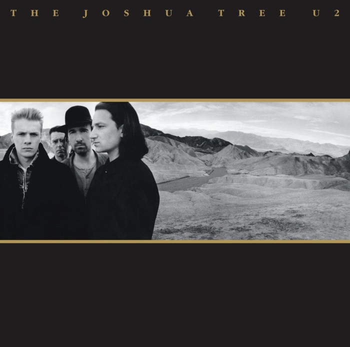
Named after Christian Brevoort Zabriskie, vice president and general manager of the Pacific Coast Borax Company in the early 20th Century, Zabriskie Point is also featured on the cover of my favorite U2 album, ‘Joshua Tree’, shown below. 'Zabriskie Point' is also the name of a 1970 movie by Italian director Michaelangelo Antonioni; its soundtrack features music by Pink Floyd and Gerry Garcia.

71-yU7mB01L._SL1500_-700x694.jpg

The strategy to shoot the moon required us to find a time when the moonset would coincide with the sunrise, so that the dynamic range of available light was manageable and we could have the setting moon in a blue sky. The moon appears largest to the human eye just above the horizon, which in this location included the beautiful mountain structure of the Panamint Range, which together with the Amargosa Range forms what is generally referred to as Death Valley.  In the shot below I chose to place the Manly Beacon in the foreground because it shows the textures and color contrasts of the eroded rock common in this area. Manly Beacon was named in honor of William Lewis Manly, who co-guided the ill-fated Forty-niners out of Death Valley during the gold rush of 1849.

IMG_3333-Edit-Edit-Edit-700x467.jpg

Zabriskie Point, January 2016

IMG_3348-Edit-Edit-700x467.jpg

Badland Formations, Zabriskie Point, January 2013

The image above was shot just after we were done capturing the setting moon. Generally referred to as the Badland Formations, this is an area of Zabriskie Point that has always caught my attention. Photographically I am drawn to the abstract nature of these formations, especially with the soft lighting present before sunrise, as was the occasion when I composed this photograph.

The next area I like visiting is Badwater Basin, noted as the lowest point in North America, with an elevation of 282 ft (86 m) below sea level. Mount Whitney (with an elevation of 14,505 feet (4421.0 m)), the highest point in the contiguous 48 United States, is only 84.6 miles (136 km) to the north west. The panorama below shows the region's floor that consists of a small spring-fed pool of "bad water" next to the road in a closed drainage basin that retains water and allows no outflow to other external bodies of water, such as rivers or oceans; the accumulated salts of the surrounding basin make it undrinkable, thus giving it the name.

IMG_3186-Edit-Edit-Edit-700x370.jpg

Badwater Basin, January 2016

The basin is the second lowest depression in the Western Hemisphere, eclipsed only by Laguna del Carbón in Argentina at −344 feet (−105 m). Adjacent to the pool, where water is not always present at the surface, repeated freeze–thaw and evaporation cycles gradually push the thin salt crust into hexagonal honeycomb shapes. On this particular visit, since the area had recently received an unusual amount of rain, the basin floor looked flat and soaked in moisture as seen above, but the image below from a 2011 shoot shows the salt crust pushed up into the hexagonal honeycomb shapes.

MG_2602-Edit-700x467.jpg

Badwater Basin, November 2011

A short drive north of this area is the turnoff to a loop road named Artists Drive, which rises up to the top of an alluvial fan fed by a deep canyon cut into the Black Mountains. Artist's Palette is an area on the face of the Black Mountains noted for a variety of rock colors. These colors are caused by the oxidation of different metals (iron compounds produce red, pink and yellow, decomposition of tuff-derived mica produces green, and manganese produces purple).

Called the Artist Drive Formation, the rock unit provides evidence for one of the Death Valley area's most violently explosive volcanic periods. The Miocene-aged formation is made up of cemented gravel, playa deposits, and volcanic debris, perhaps 5,000 feet (1500 m) thick. Chemical weathering and hydrothermal alteration cause the oxidation and other chemical reactions that produce the variety of colors displayed in the Artist Drive Formation. We did not get an opportunity to shoot the Artist's Palette during this visit, but have chosen to include the image below from a photo shoot from a couple of years ago.

IMG_1384-Edit-700x467.jpg

Artists Palette, February 2014

The average annual precipitation in Death Valley is 2.36 inches (60 mm), while the Furnace Creek Ranch area, where we stayed, averaged 1.58 in (40 mm).The wettest month on record is January 1995 when 2.59 inches (66 mm) fell on Death Valley. The wettest period on record was mid-2004 to mid-2005, in which nearly 6 inches (150 mm) of rain fell in total, leading to ephemeral lakes in the valley and the region and tremendous wildflower blooms.Snow with accumulation has only been recorded in January 1922, while scattered flakes have been recorded on other occasions.

Considering this very low annual precipitation I was pleasantly surprised a couple of years ago to discover pools of standing water in is an area named Cottonball Basin, located about 4 to 8 miles north of Furnace Creek. This is not an area easy to find as it is quite difficult to see these pools of water from the road. The water is fed from underground springs and evaporates very quickly, making it difficult at times to find, although it provides a beautiful reflective surface for any clouds in the sky at sunrise, sunset or even midday. After we checked into the hotel in Furnace Creek on our initial arrival, we drove north along Highway 190 about 45 minutes before sundown. I thought I saw water in an area about 6 miles out of Furnace Creek and took the chance that we could find it and headed out to set up and shoot the sunset, hoping to have clouds reflected in the water we may find. The image below is from that shoot looking southward into the Valley.

IMG_3158-Edit-700x467.jpg

Cottonball Basin, January 2016

The next day we decided to search the area with plenty of time before the sunset, and spent a great deal of time and effort looking for an ideal spot that would provide us with a larger pool of water. We walked many a mile and ended up finding another area, and again was fortunate to have clouds in the sky to create interesting and colorful reflections in an area renowned for very low rainfall and famous for its heat and sand dunes. Here is a shot of the four of us during the afternoon's search.

IMG_3381-Edit-Edit-700x467.jpg

Cottonball Basin, 2016

From right to left ~ Michael Heathman, Eric Emerson, Kim Porter, David Grenier

IMG_3294-Edit-Edit-2-700x467.jpg

Cottonball Basin, January 2016

The image above, of the sunset on our second night, is looking north with the Amargosa Range on the right hand side of the Valley, and a thunderstorm occurring to the left of the image in about the direction of the Mesquite Flat Sand Dunes area. As the sun went down the color of these clouds took on a bright yellow/orange hue but also diminished in size and volume, which made me select this shot to include in my blog.

Although our recent trip did not allow us to visit this area, Rhyolite is a ghost town in Nye County, in the U.S. state of Nevada, well worth visiting, especially at sunset. It is in the Bullfrog Hills, about 120 miles (190 km) northwest of Las Vegas, near the eastern edge of Death Valley. The town began in early 1905 as one of several mining camps that sprang up after a prospecting discovery in the surrounding hills. During an ensuing gold rush, thousands of gold-seekers, developers, miners and service providers flocked to the Bullfrog Mining District. Many settled in Rhyolite, which lay in a sheltered desert basin near the region's biggest producer, the Montgomery Shoshone Mine.

IMG_9489-Edit-Edit-700x467.jpg

Rhyolite Cook Bank Building remains, November 2013

Industrialist Charles M. Schwab bought the Montgomery Shoshone Mine in 1906 and invested heavily in infrastructure, including piped water, electric lines and railroad transportation, that served the town as well as the mine. By 1907, Rhyolite had electric lights, water mains, telephones, newspapers, a hospital, a school, an opera house, and a stock exchange. Published estimates of the town's peak population vary widely, but scholarly sources generally place it in a range between 3,500 and 5,000 in 1907–08.

Ryholite-Star-Trails-11-13-2013-Edit-600x900.jpg

Star Trails, Rhyolite Cook Bank Building, November 2013

Rhyolite declined almost as rapidly as it rose. After the richest ore was exhausted, production fell. The 1906 San Francisco earthquake and the financial panic of 1907 made it more difficult to raise development capital. In 1908, investors in the Montgomery Shoshone Mine, concerned that it was overvalued, ordered an independent study. When the study's findings proved unfavorable, the company's stock value crashed, further restricting funding. By the end of 1910, the mine was operating at a loss, and it closed in 1911. By this time, many out-of-work miners had moved elsewhere, and Rhyolite's population dropped well below 1,000. By 1920, it was close to zero.

Last, but not least on my list of favorite places are the sand dunes in the Park, while famous, are not nearly as widespread as their fame or the dryness of the area may suggest. The Mesquite Flat Sand Dunes field is the most easily accessible from the paved road just east of Stovepipe Wells in the north-central part of the valley and is primarily made of quartz sand. Another dune field is just 10 miles (16 km) to the north but is instead mostly composed of travertine sand. The highest dunes in the park, and some of the highest in North America, are located in the Eureka Valley about 50 miles (80 km) to the north of Stovepipe Wells, while the Panamint Valley dunes and the Saline Valley dunes are located west and northwest of the town, respectively. Prevailing winds in the winter come from the north, and prevailing winds in the summer come from the south. Thus the overall position of the dune fields remains more or less fixed.

During this particular trip we visited Mesquite Flat Sand Dunes three times, albeit it the first time for a sunrise was very brief, where we encountered heavy cloud cover rendering the color on the dunes flat and monotone. Breakfast in a warm restaurant was calling and we responded instead! The second time out we visited Hell's Gate hoping to shoot a sunset, which we did not think was going to occur as we hoped, so we decided to visit the dunes area again more or less as a scouting exercise for the sunrise the next morning, our last opportunity to shoot the dunes.

IMG_3400-Edit-700x467.jpg

Mesquite Flat Sand Dunes, January 2016

Truth be told, I was on the way out of the dunes area with another photographer because the light was again monotone and flat, when all of a sudden there was an opening in the sky that suddenly started to get some color on the eastern horizon. I know from experience that weather can change quickly and patience sometimes pays off. When the conditions started to change rapidly I knew we were out of position to shoot with the dunes in the foreground, so I managed to scramble around and find the composition above and catch the color, a small sand dune and desert bush.

IMG_3419-Edit-2-700x467.jpg

Mesquite Flat Sand Dunes, January 2016

Just when the sunset towards the east began to loose its color, my attention was brought to the sky towards the west, where the sun had gone down and the sky blew up with color that I had never seen in Mesquite Flats Sand Dunes previously. Again, after a mad scramble I was able to capture the image above, which I consider a good consolation for being so far out of position! This evening's shoot gave me an idea of what to expect in this area, one I had not been to previously. The main parking lot that accommodates visitors to the dunes, while providing great access to the highest dunes in the area, omnipresent footprint unfortunately spoil most potential compositions, essentially ruining the area for photographers. It reminds me of my days as a surfer, where one was always looking to find places that weren't crowded, where surfing beautiful waves with a couple of friends was the ideal scenario.

This particular spot, a good distance away from the main parking lot, provided access to medium size dunes and less footprints, albeit more than I would have liked. Dawn's first light is a spectacular time to be photographing on the dunes, with the amazing windswept patterns in the sand being lit up by the low light providing an overwhelming selection of compositions that are simply delightful to witness and photograph. The following images are from the next morning's shoot, where we arrived just after 6:30 am and walked out into the dunes under the bright light of a setting full moon, with the sunrise set to come over the horizon at about 7:10 am. Here are three more images, shown below, from our morning shoot on our last day in Death Valley. The sensual shapes, lines, textures, shadows and light are a photographers dream, and simply stunning to experience and witness in person.

IMG_3439-Edit-3-700x469.jpg

'One Small Step...' ~ Mesquite Flat Sand Dunes, January 2016

IMG_3461-700x467.jpg

Mesquite Flat Sand Dunes, January 2016

IMG_3470-700x467.jpg

Mesquite Flat Sand Dunes, January 2016

So there you have it, a summary of my favorite places to visit in the magnificent Death Valley National Park, with some history and points of interest (thanks to Wikipedia and the National Park Service), as well as images that I hope will peak your interest to visit someday. I also need to tell you that I am only scratching the surface of things to see and do here, and a great place to begin when you get to the Park is stop by the Furnace Creek Visitor Center and talk to one of the Park Rangers, who are extremely friendly and helpful to all visitors. A 20 minute park film is shown throughout the day. During the winter season, November to April, rangers present a wide variety of walks, talks, and slide presentations about Death Valley's cultural and natural history. Additional programs may be presented at other times. Inquire at the visitor center for current programs. Death Valley is truly a unique experience and the variety of places to visit could keep you engaged and busy for days.

Enjoy!

2015 Top Twelve Photographs of the Year

“Twelve significant photographs in any one year is a good crop.”~ Ansel Adams

It is my pleasure, albeit a lot of work, to continue an annual tradition that I began in 2013, where I gather and publish my top Twelve Photographs of the year. This tradition stems from the quote above attributed to Ansel Adams, one of the most recognized names of photographers in the modern era, particularly famous for his magnificent black and white photographs of Yosemite National Park. His quote is a conscious thought that guides me during most of my photoshoots, where I remind myself that realistically I am looking for just one or two images that will be significant and capture the essence of what I am looking at in the field.

When you shoot a few thousand images as I do on an annual basis it is difficult to cull this all down to 'twelve significant photographs' so, as in previous years, I determine the Top Twelve, and the order of the selections, by looking back at my Facebook page and noting how many Likes/Comments I received when they were originally posted on my wall. I am fully aware that this is far from scientific or could be argued that it is downright arbitrary, but that is the method I have used and will continue to do so again this year.

I was fortunate to have traveled and created opportunities to shoot in a wide variety of places in 2015. From my favorite venues such as Yosemite National Park, Mono Lake, Bodie Historical State Park, Mt. Tamalpais in Marine County, and the Central Coast in California, I also made it back to the country of my birth Sri Lanka again, and spent a month in my 'second home', Australia.  A first time for me this year I had an opportunity to visit Page, Arizona and the amazingly colorful slot canyons of Lower Antelope Canyon and Secret Canyon. As a photographer, I consider myself lucky to live in El Dorado Hills, just 30 miles northeast of Sacramento, as it allows me to get to some of the most beautiful National and State Parks within a four to five hour drive from my home.

So again this year I will count them down starting with Number 12, give you the Facebook vote count, say something about each image, and provide some basic EXIF data.

#12 - (120 votes) 'Where Angels Tread' ~ California has been in a significant drought for the last four years when an unexpected spring storm went through Yosemite, dumping significant snow at higher elevations. I drove into the Park and went down to a favorite spot on Southside Drive to capture these beautiful reflections of the Three Brothers in the Merced River.

IMG_4347-Edit-700x467.jpg

May 7, 2015, Three Brothers, Yosemite National Park, California, exposure 1/5 sec @ f/11; 16-35 mm lens at 19 mm; ISO 100

#11 - (122) 'Hot Summer Nights' ~ we had been experiencing triple digit heat for a couple of days in a row, with the temperature only dropping down into the 90's at night when I decided to go shoot the sunset at this 'new' location, about 20 minute drive from my home. I have a love for oak trees, especially located on top of the rolling hills in this area that silhouette against the sky, which was filled by this typical Northern California summer evening's clouds that get lit up by a sunset. I used a higher ISO setting in order to freeze the moving grass stems due to the presence of a stiff breeze this particular evening.

IMG_6843-700x467.jpg

June 26, 2015, Scott Boulevard, Rancho Murrieta, California, exposure 1/10 @ f/11, 16-35 mm lens @ 16 mm, ISO 800

#10 - (123) 'Turbulence' ~ there is something about the intensity of tropical sunsets that sets them apart, and this one shot in a town called Koggala, on the south western side of the island of Sri Lanka was no exception. I decided to go down to this beach area, a short walking distance from the hotel we were staying in despite the prospects for a great sunset looking fairly slim. However, I knew from experience, even though the sky was laden with heavy clouds as long as an opening existed above the horizon the chances were good that the sky could develop into a good sunset. I was so glad to have been right on this particular evening!

IMG_8838-Edit-700x467.jpg

August 31, 2015, Koggala, Sri Lanka, exposure 0.6 secs @ f/14, 24-105 mm lens @ 35 mm, ISO 200

#9 - (125) 'Double Trouble' ~ we had an amazing storm move through the area this particular evening, bringing with it rain, lightning, thunder and gnarly looking clouds. I went to shoot from a favorite location of mine locally, about 10 minutes drive from my home, and while I was composing and shooting the sunset scene, intuitively I turned around 180 degrees behind me to find this beautiful double rainbow and magnificent sky. The title of this image is a dedication it to the late Stevie Ray Vaughn and his band Double Trouble, that were recently inducted into the Rock and Roll Hall of Fame!

IMG_6503_HDR-Edit-2-Edit-700x468.jpg

June, 5, 2015, Scott Boulevard, El Dorado Hills, California, exposure 1/3 sec @ f 11, 16-35 mm lens @ 16 mm, ISO 125

#8 - (127) 'El Capitan's Evening Light' ~ shot on the evening of my birthday, April 7, this magnificent granite monolith, named "El Capitan" by the Mariposa Battalion when it explored the valley in 1851, meaning "the captain", "the chief", was taken to be a loose Spanish translation of the local Native American name for the cliff that extends about 3,000 feet (900 m) from base to summit along its tallest face. I used a polarizing filter on this shot, which allows the beauty of the reflection in the Merced river to shine through in detail, and interestingly the only vertical image in this collection!

IMG_3939-Edit-600x900.jpg

April 7, 2015, El Capitan, Yosemite National Park, California, exposure 1/5 sec @ f/11, 16-35 mm at 16 mm, ISO 100

#7 - (133) 'Synchronicity' ~ spent Christmas afternoon with my three adult children and their extended family enjoying great food and conversations! The backyard of the home we had dinner in was a magnificent wide wet sand beach, which acted like a gigantic reflective mirror that perfectly duplicated these early sunset clouds. Pajaro Dunes Beach is in Watsonville, and the width of the beach was in part due to a tidal range of just over 7.5 feet on the day caused by the full moon, the first on Christmas Day in 38 years!

IMG_2948-Edit-700x467.jpg

December 25, 2015, Pajaro Dunes Beach, Watsonville, California, exposure 1/13 sec @ f/11, 16-35 mm leans @ 21 mm, ISO 125

#6 - (142) 'Awakening' ~ I had not been to the Hawaiian Island in a few years, and I had never visited the island of Maui. This was a sunrise at Koki Beach, just south of Hana on the east coast of Maui. The large red cinder hill to the left is Ka Iwi o Pele, 'the Bones of Pele', that is the remnant of a volcanic vent, and according to a Hawaiian legend, the Goddess Pele was killed near this place by her older sister, and her bones were piled up to make this hill. Her spirit fled southeast from this point to the Big Island, where is is said to still reside today. In more recent times, this hill now belongs to Oprah, as part of a 105 acre parcel that she bought from Hana Ranch in 2002.

IMG_5053-Edit-Edit-Edit-700x467.jpg

May 20, 2015, Koki Beach, Maui, Hawaii, exposure 0.3 sec @ f/22, 16-35 mm lens at 16 mm, ISO 125

#5 - (153) 'Tropical Playground' ~ this was the first image of a sunset trilogy captured at Koggala, south west Sri Lanka, shot on the beach in front of our hotel. The second image of the trilogy is shown in image #10 above. I have never seen clouds like this develop into these awesome formations, highlighted by magical light that placed emphasis in just the right places. It is beyond good fortune to travel half way round the world to witness and photograph the unrivaled beauty of Mother Nature at her finest!

IMG_8763-Edit-Edit-700x467.jpg

August 31, 2015, Koggala, Sri Lanka, exposure 10.6 secs @ f/22, 24-105 mm lens at 24 mm, ISO 125

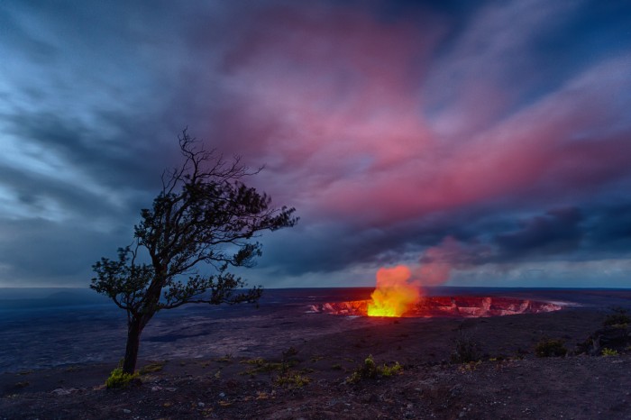
#4 - (154) 'Kīlauea Sunrise' ~ we spent the first two nights of our Hawaii photoshoot on the Big Island, and this was a 5:00 am shot of the glow generated by the lava lake in Kīlauea, a currently active volcano, and the most active of the five volcanoes that together form the island of Hawaiʻi, and, perhaps, the most active volcano on earth. There is something very primal and attractive for us humans to see molten lava, which builds and yet destroys, and is completely uncontrollable by mankind.

IMG_4407_HDR-700x466.jpg

Kilauea, Big Island, Hawaii, this is an HDR blend of 3 images, exposure @ f/4, 16-35 mm lens @ 16 mm, ISO 1,600

#3 - (195) 'Full Moon Rising' ~ shot this from my backyard in El Dorado Hills, in what turned out to be the final Supermoon of 2015. If you missed this night's show, you will have to wait until October 2016 to see another one. It was the sixth Supermoon of the year and came just a month after another Supermoon, which also happened to be a total lunar eclipse. This night's full moon meant the orb not only appeared brighter but also larger than normal – about 14 percent bigger than a normal moon. In 2016 there will be 3 Supermoon's, beginning in October, as mentioned above, with November and December's moons also being classified as Super.

IMG_0599-Edit-Edit-Edit-Edit-700x467.jpg

October 26, 2015, El Dorado Hills, California, exposure 0.8 secs @ f/8, 400 mm lens plus 1.4 converter @ 560 mm, ISO 100

#2 - (233) 'Morning Has Broken' ~ one last image shot in 2015, from my Yosemite shoot at the end of December. Found myself at the Gates of the Valley AKA Valley View, with morning light hitting El Capitan just right to create this beautiful reflection in a fairly still and frozen in patches, Merced River. This, along with Tunnel View are two of the classic locations for photographer's in Yosemite Valley, and this particular spot provides a beautiful reflective opportunity of El Capitan and the Cathedral Rocks on the right, that include Bridalveil Falls, which was somewhat frozen during this particular winter's day.

IMG_3042-Edit-Edit-Edit-Edit-700x467.jpg

December 27, 2015, Valley View, Yosemite National Park, California, exposure 0.3 secs @ f/11, 16-35 mm lens @ 16 mm, ISO 100

#1 - (300) 'A Milky Way' ~ one of my favorite images from a photoshoot at Mt Tamalpais on May 2, with my daughter Michelle Grenier, an accomplished photographer in her own right (www.instagram.com/michiesharine/?hl=en) as my guide. We were very fortunate to have a magnificent layer of coastal fog move in to make this simply a magical sight and photo opportunity! I decided to use a high ISO setting because of the presence of a stiff breeze and I wanted to make sure that the grass and trees in this shot weren't blurred by the wind in the resulting photograph.

IMG_4265-Edit-2-700x467.jpg

May 2, 2015, Mt Tamalpais, Marine Country, California, exposure 1/8 sec @ f/11, 24-105 mm lens at 50 mm, ISO 1,200

There you have it, my third annual Top 12 Photographs for the 2015 year. A few observations in closing - 1. Eight of the images voted on were shot in California locations, 2. two were from Sri Lanka, and 3. the remaining two were from my Hawaiian Islands shoot. It is interesting for me to compile these images every year and realize the wonderful accomplishment I was privileged to be allowed to complete by traveling to these beautiful locations, as well as what excellent tastes and insights that the followers of my Facebook page have displayed, and how much these people help in my selection process at the end of each year. So a big thank you to all these people for taking the time to do so - greatly appreciated!

In conclusion, and as always, I owe a great deal of gratitude to the many, many people who support my photography by purchasing my images in print form, as well as the hundreds of Likes and Comments that so many people take the time to stop by and leave on my Facebook page at  http://facebook.com/djgrenier , and last not least, the photographers and friends of mine that I travel and live with during these photographic journeys through out the year - again, my deepest thanks!

Looking forward to 2016 and wishing everybody a Wonderful New Year!

A Short History of Grenier Road, Colombo, October 2015

Some of my family and friends are aware that I have been working on republishing my father's book of short stories entitled 'Isle of Eden'. To that end I have been working with a Mr. Sam Perera of Perera-Hussein Publishing (www.pererahussein.com) in Colombo, Sri Lanka, who has been a friend and supporter of this project for some time now, and did a great job proof reading the final manuscript for me. I informed Sam that I would be visiting Sri Lanka in August and would like to meet and have lunch with him when I got to Colombo. He accepted my invitation and wrote back 'You probably know there is a street in Colombo that carries your last name. Probably an illustrious ancestor.' I did not know, nor was my family aware of the existence of Grenier Road when we lived in Colombo in the early '50s, so I was delighted to locate and visit the street that carries my family name with my travel companions and cousins Michael and Sharlene Roosmale-Cocq on September 3, 2015, where the photograph below was taken.

The sign is written in Sinhalese, Tamil and English, in descending order. As an aside, I look back in amazement that several years of my schooling outside of Colombo was done completely in the Sinhala language, which I spoke fluently and wrote proficiently/daily in the beautiful characters of the Sinhalese alphabet, as seen below.

IMG_8921-Edit

Coincidentally I also came to realize that I was born at De Soysa Maternity Hospital, less than a quarter mile from this sign, which helped prompt me to ask the obvious question 'who was the street named after?', and the follow up to that, 'was this an illustrious ancestor?'. While in Colombo during the last days of our visit I did some research via Google to no avail. Michael picked up the research when he got back to Australia and discovered the following information - Grenier Road was named in 1886 after the first secretary of the Colombo Municipal Council - Sir Samuel Grenier.

I was excited, to say the least, when I received this information and immediately went to a comprehensive copy of my family genealogy to discover that, Sir Samuel Grenier was my great, great, grandfather’s elder brother!

A brief synopsis of the illustrious Samuel Grenier's life - Sir John Samuel Charles Grenier, born 16 June 1840 in Jaffna, Northern Province, Ceylon; died 31 October 1892 in Colombo, Western Province, Ceylon.

Samuel had high intellectual gifts and was appointed Headmaster of the Central School when only 20 years of age. On traveling to Colombo he gained a job as sub-editor of a newspaper 'The Examiner', while continuing his legal studies until in 1864 when he passed the Advocate examinations. He next became the first Secretary of the Colombo Municipal Council, age 24.

In 1876 he was offered and accepted an appointment to the Supreme Court Bench. He eventually went on to be appointed Attorney General of Ceylon, receiving his Knighthood in 1891 from the Queen of England, Her Royal Majesty Queen Victoria, a year before his passing,

Gives new meaning to the phrase 'its a small world'.................

Negombo, Sri Lanka, August, 2015

I spent the first few days of my journey back to Sri Lanka in one of my favorite towns in this country, Negombo, just north of Colombo, the country's capital. It is home to the country's main airport, Bandaranaike International, named after former Prime Minister S.W.R.D. Bandaranaike. He was the fourth Prime Minister of Ceylon (later Sri Lanka), serving as Prime Minister from 1956 until his assassination by a Buddhist robe wearer in 1959. Bandaranaike's widow Sirima Ratwatte Dias Bandaranaike, went on to become the world's first female Prime Minister, elected to office in July 1960. But I digress, as I originally began to describe my familial connection to Negombo, which goes back to my grandfather, on my mother's side, who was born in Negombo, married my grandmother Ruth Modder in St. Stephen's Church in Negombo. My mother, Sheila (Modder) Grenier, and her 5 siblings were all born in Negombo, and she married my father, Ronnie Grenier, in the same St. Stephen's Church. I lived in Negombo from the age of 4 until I left at the age of 10 to live in a town named Badulla.

My earliest memories of my childhood goes back to Negombo, where I first began a life-long affinity for the ocean and became familiar with the catamaran, the vessel used by the local fisherman to take them a few miles out to sea to catch their fish that they sell at the local fish markets to eek out a meager living. These vessels were originally built by hollowing out a tree trunk, but the progress of man has brought us into a new era and the boats used now are all fiberglass, making them much more durable and safer than their dugout predecessors.

IMG_7363-Edit-Edit-700x467.jpg

The image above shows a typical morning with fishing boats returning home after being out all night. On this particular morning the seas were rough with a strong onshore wind blowing at about 20 knots, making it a tough slog navigating these vessels through the uneven swells.

IMG_7358-Edit-Edit-Edit-Edit-700x467.jpg

I found this fishing boat, a relic of my past as a child growing up in Negombo, lying along the beach just north of where I stayed. It was a vessel used many years ago by Sinhala fisherman for carrying out a massive net cast out in the ocean and then dragged into the shore trapping all and sundry in its wake. I remember it being 'huge' as a child and but found it much smaller in real life - funny how that works!

IMG_7402-Edit-Edit-Edit-700x467.jpg

It takes quite some skill and experience to bring these catamarans into the shore, including getting past and navigating through the shore break, as show above.

IMG_7378-Edit-Edit-Edit-700x467.jpg

My eye caught the beautiful morning's low light as these catamarans were fishing just outside the fishing village of Palangathure, Negombo.

IMG_7406-Edit-Edit-Edit-2-700x477.jpg

'Homeward Bound' ~ caught this catamaran coming into shore, into a small fishing village named Palangathure, Negombo. It is a Muslim community, as can be evidenced by the golden domes of their mosque in the background, and that's why they were out fishing on a Sunday morning. They will unload the fish they caught and sell it immediately to the highest bidder in the village. It's a hard life these sea faring men live as they have done for many, many years.

I will always have a special place in my heart for Negombo, and its fisherman, and the beautiful catamarans they utilize to go out to sea and make their catch, the very basis of their existence and livelyhood!

Enjoy!

Adventures in Hawaiʻi, June 2015

I had the pleasure of journeying back to the Hawaiian Islands in May 2015 for a photoshoot, together with two photographer friends, Eric Emerson and Michael Heathman, both accomplished fine art photographers from California. I have travelled to Hawaiʻi at least twenty times over the last 15 years, a place that I feel very much at home because it reminds me of my original birth island, Sri Lanka, in many ways as it is tropical, with mild yet humid temperatures year round, an easy laid back style of living, and monsoonal rains that are typical of the tropics. A little about Hawaiʻi from Wikipedia: Hawaiʻi is the 50th and most recent US State to join the United States, having joined on August 21, 1959. Hawaiʻi is the only U.S. state located in Oceania and the only one composed entirely of islands. It is the northernmost island group in Polynesia, occupying most of an archipelago in the central Pacific Ocean. Hawaiʻi is the only U.S. state not located in the Americas. The state does not observe daylight savings time.

The state encompasses nearly the entire volcanic Hawaiʻian archipelago, which comprises hundreds of islands spread over 1,500 miles (2,400 km). At the southeastern end of the archipelago, the eight main islands are—in order from northwest to southeast: Niʻhau, Kauaʻi, Oʻahu, Molokaʻi, Lanaʻi, Kahoʻolawe, Maui and the Island of Hawaiʻi. The last is the largest island in the group; it is often called the "Big Island" or "Hawaiʻi Island" to avoid confusion with the state or archipelago. 

The trip this year took us to the Big Island (2 nights) and Maui (8 nights). On the Big Island a goal was to shoot the Milky Way from the look out at Kilauea, with the cauldron ablaze on the ground, compositionally aligned with the Milky Way in the Heavens. In Maui I did not have any specific goals as this was my first visit, and hoped to capture a tropical sunrise and sunset, famous and common in these islands. In this blog post I have included six of my favorite images from the trip, as well as a wider selection in the form of a slideshow in an iMovie embedded below.

IMG_4379-Edit-2-Edit-Edit-Edit-2-700x467.jpg

'Fire in the Stars' ~ Kilauea ablaze and the Milky Way aglow, the only chance we were given to capture both attractions, on the morning of May 16, 2015 at 4:31 am. It was an inspiring, albeit fleeting moment to witness both before the reddish clouds above the glowing lava in the cauldron moved over to block visibility of the Milky Way. Our attempt to shoot this again the next morning were thwarted by heavy rains, so this was the only shot I managed to sneak away with from this magical sight!

IMG_4407_HDR-700x466.jpg

'Kīlauea Sunrise' ~ this was a 5:00 am shot of the glow generated by the lava lake in Kīlauea, a currently active volcano, and the most active of the five volcanoes that together form the island of Hawaiʻi, and, perhaps the most active volcano on earth. There is something very primal and attractive for us humans to see molten lava, which builds and yet destroys, and is largely uncontrollable by mankind!

IMG_5053-Edit-Edit-Edit-700x467.jpg

'Awakening' ~ sunrise at Koki Beach, just south of Hana on the east coast of Maui. The large red cinder hill to the left is Ka Iwi o Pele, where Hawaiian Mythology tells the bones of Pele were left after a fatal battle with her older sister. In more recent times, this hill now belongs to Oprah, as part of a 105 acre parcel that she bought from Hana Ranch in 2002. Pele, the Fire Goddess, is the goddess of fire, lightning, wind and volcanoes and the creator of the Hawaiian Islands.

IMG_4597-Edit-2-Edit-Edit-Edit-700x467.jpg

'Lion de la Mer' ~ I captured this image in a little cove just south of Hana on the east coast, very close to the house we had rented that we stayed in for four nights. This was my first visit to Maui (haven't been on a Hawaiian island yet that I did not like), and if you look closely you will find the Lion of the Sea!

IMG_5404-Edit-Edit-Edit-700x467.jpg

'Maui Sunset' ~ we have had two evenings of spectacular sunsets, this one being from our first day in Kihei, located in south west Maui (on the horizon, the islands of Lanaʻi to the right, and Molokaʻi in the middle).

IMG_6353-Edit-Edit-700x467.jpg

'Swept Away' ~ our final sunset on the last day of our visit to Maui, captured at La Perouse Bay or Keoneʻoʻio Bay, which is located south of the town of Wailea.  The bay's Hawaiian name is Keoneʻoʻio. It was later named for the French explorer Captain Jean-Francois de Galaup, compte de La Perouse, who, in 1786, surveyed and mapped the prominent embayment, and is the site of Maui's most recent volcanic activity.

Another item of interest about Hawaiʻi, from Wikipedia ~ The Hawaiian language takes its name from the largest island, Hawaiʻi, where it developed, originally from a Polynesian language of the South Pacific, most likely Marquesan or Tahitian. The island name was first written in English in 1778 by British explorer James Cook and his crew members. The Hawaiian alphabet only uses 12 Roman letters - a, e, i, o, u, h, k, l, m, n, p, w; five vowels (long and short) and eight consonants, one of them being a glottal stop (ʻ) (called ʻokina in Hawaiian).

Captain James Cook was a British explorer, navigator, cartographer, and captain in the Royal Navy. Cook made detailed maps of Newfoundland prior to making three voyages to the Pacific Ocean, during which he achieved the first recorded European contact with the eastern coastline of Australia and the Hawaiian Islands, and the first recorded circumnavigation of New Zealand. Cook was killed in Hawaii in a fight with Hawaiians during his third exploratory voyage in the Pacific in 1779. He left a legacy of scientific and geographical knowledge which was to influence his successors well into the 20th century and numerous memorials worldwide have been dedicated to him.

In closing, I am often asked 'what is your favorite Hawaiian island'? It is difficult for me to choose just one (I have visited Kauaʻi, Oʻahu, Maui and the Island of Hawaiʻi), as each island is different, has it's own uniqueness and charms. But if I absolutely must choose one from the perspective of a landscape photographer, I would go with Kauaʻi, often referred to as the 'Garden Isle', for good reasons!

Mahalo to these magical island for now, and look forward to my next visit!

https://www.youtube.com/watch?v=IG47zZxglpo

Mount Tamalpais, May 2015

My daughter, Michelle Grenier, invited me to join her on a photo shoot in one of her most favorite areas, Mount Tamalpais State Park. Michelle is an accomplished iPhone photographer, with over 100,000 followers on Instagram. https://instagram.com/michiesharine/.

She also conducts iPhone Photography Workshops and Mt Tamalpais is an area she frequently brings her student to, as discussed in this interview.

http://www.theimageflow.com/2014/10/9-questions-moment-iphone-photographer-michelle-grenier/

So I was honored and very excited to be asked to join her on a personal tour and of an area that she is intimately familiar with on May 2, 2015. This coastal area of Marin County, just north of San Francisco, is renowned for its rolling hills and coastal fog, which provides beautiful and unique opportunities for a photographer. We both had our fingers crossed for the a presence a good marine layer during the sunset, and our wishes were granted in abundance! According to Michelle, we had the best fog conditions that she had ever seen in all of the many times that she had been in the area. So below, you will find a few of the highlights of our evening together, and an iMovie that I created that includes a video that Michelle shot of the fog during the closing minutes of the sunset.

To begin, I have included extracts from the official Mount Tamalpais State Park brochure, in order to give you some history and background of the area.

Mt Tamalpais State Park

"Just north of San Francisco's Golden Gate is Mount Tamalpais.  It has redwood groves and oak woodlands with a spectacular view from the 2,571-foot peak. On a clear day, visitors can see the Farallon Islands 25 miles out to sea, the Marin County hills, San Francisco and the bay, hills and cities of the East Bay, and Mount Diablo. On rare occasions, the Sierra Nevada's snow-covered mountains can be seen 150 miles away.

Coastal Miwok Indians lived in the area for thousands of years before Europeans arrived. In 1770, two explorers named the mountain La Sierra de Nuestro Padre de San Francisco, which was later changed to the Miwok word Tamalpais. With the Gold Rush of 1849, San Francisco grew and more people began to use Mount Tamalpais for recreation. Trails were developed and a wagon road was built. Later, a railway was completed and became known as "The Crookedest Railroad in the World." It was abandoned in 1930 after a wildfire damaged the line.

Many people think the 2,571-foot peak is the remnant of an extinct volcano. However, geologists believe that Mount Tamalpais was created due to its location near the San Andreas Fault, one of the world's most active faults. Over time, the mountain has risen from the earth's crust, while erosion has left only solid rock exposed in the highest peaks and ridges."

Earlier in the afternoon we first spent some time walking around the Fire Lookout, built atop the East Peak, that at 2,571 feet provides a spectacular, unencumbered 360 degree view of the San Francisco Bay area. It is also the highest point of the State Park. We then headed down to the West Entrance and began to drive down Highway 1, and this is one of the first images that I captured of the beginning sunset and the marin fog that had rolled in that evening.

IMG_4184-Edit-Edit-700x467.jpg

My second image was captured a little ways down the road at this point, where the low light and fog filled coastline was beginning to look simply spectacular.

IMG_4190-Edit-700x467.jpg

Just about now it began to be clear to me that I was very fortunate to have Michelle as my guide, because there wasn't a great deal of time to 'discover' where to go and when to be there to capture the fog and the setting sun. Since she had been here so many times before Michelle simply knew this area so well, we were always in the right place at the right time!

IMG_4193_HDR-Edit-700x466.jpg

The fog on this particular evening was driven in by a strong onshore wind, giving us spectacular volumes of glorious white waves of fog that filled the nooks and crannies of this Marin County coastline. Here is a shot of the setting sun shot from a beautiful vantage point that shows the vastness and depth of the marine layer on this beautiful evening.

IMG_4234_HDR-Edit-700x440.jpg

The image below was shot from a place that Michelle directed me to, telling me to 'come over here, it's a great view'. This has turned out to be one of my top 5 most popular images of all time, and all credit goes to my daughter!

IMG_4265-Edit-2-700x467.jpg

I would like to end this blog post by adding the last image I captured at the end of this amazing evening, a haunting image of the fog intermixed with the coastal pines that are abundant in the rolling terrain of Mt Tamalpais.

IMG_4253-Edit-700x467.jpg

And last but not least, I have included a link to an iMovie that includes the images that highlight the evenings photo shoot, as well as a brief video of the rolling streams of fog that was captured by Michelle on an iPhone.

Enjoy!

https://youtu.be/gV31qGZxTMM

Big Sur, California: A Journey in Black & White, April 2015

Next to Yosemite National Park, Big Sur, on the Central Coast of California holds a very special place in my heart. I have been fortunate to visit this area many times over the last 30 plus years and it never disappoints me with its magnificence and rugged beauty. Recently I was invited to visit the area again by a very special person in my life, three days before my 70th birthday, a journey that allowed me to share with her some of the places that I like to photograph and simply enjoy its breathtaking beauty. I would like to take this opportunity to publish a few of the images shot during this special time, a journey as it turns out that led to a renewed affinity for black and white photography, that goes all the way back to my first introduction into photography by my father in the early 50's in the land of my birth, Ceylon, now Sri Lanka. According to Wikipedia: "Big Sur is a sparsely populated region of the Central Coast of California where the Santa Lucia Mountains rise abruptly from the Pacific Ocean. Although it has no specific boundaries, many definitions of the area include the 90 miles (140 km) of coastline from the Carmel River in Monterey County south to the San Carpoforo Creek in San Luis Obispo County. The name 'Big Sur' is derived from the original Spanish-language 'el sur grande', meaning 'the big south', or from 'el país grande del sur', 'the big country of the south'. This name refers to its location south of the city of Monterey."

It is interesting to note here that I had a hard time getting excited about any of my images that I captured while in Big Sur this time, and felt very uninspired when I got back home and began the process of reviewing and developing various images. That is until I saw a black and white post on a fellow photographers Facebook page and it gave me an idea to look at what an image I had shot in color may look like in black and white, and there it was! It changed the dynamic of everything instantly and I continued to develop these images with my new found inspiration until I was finally excited about what I had captured!

'Maybe black and white is the best medium for landscapes, I don't know.' ~ Fay Godwin (17 February 1931 – 27 May 2005) was a British photographer known for her black and white landscapes of the British countryside and coast.

IMG_3660-Edit-2

My Big Sur journey on this day began by stopping off at a spot that is named Soberanes Point, which is a great place to view both the ruggedness and beauty of this coastline. On this particular day we were fortunate to have fairly heavy seas and a cloudy sky to add some drama photographically to these landscapes.

IMG_3631-Edit-Edit-Edit

The next stop was a little place that I like to go to just below the parking lot at Rocky Point. Again from here you are able to see the beauty of this coastline and the dramatic Santa Lucia Mountains that rise abruptly from the Pacific Ocean.

IMG_3774-Edit-Edit-Edit

Further south along the journey was a stop at Bixby Creek Bridge, also known as Bixby Bridge, a magnificent engineering structure that was first opened in 1932, built under budget for $199,861, and is still one of the tallest single span concrete bridges in the world.

IMG_3795-Edit-2

Pfeiffer Beach is a hard to find beach at the end of unmarked Sycamore Canyon Road, which is the only paved, ungated road on the west side of Highway One between the Big Sur Post Office and Pfeiffer Big Sur State Park. This a favorite place for photographers in the month of December and early January when they congregate at this huge rock structure to capture the sunset light that shines through Keyhole Archway.

IMG_3785-Edit

Just north of the structure above is this beach that is always an interesting photographic opportunity, particularly on any day with a cloudy sky and a significant swell running in the ocean.

IMG_3825-Edit

Continuing the drive south on Highway 1 for about 12 miles you arrive at Julia Pfeiffer Burns State Park. The park is named after Julia Pfeiffer Burns, a respected resident and rancher in the Big Sur region in the early 20th century, who lived in the area for much of her life until her death in 1928. The 3,762-acre (1,522 ha) park was established in 1962.

IMG_3850-Edit

A main feature of the park is McWay Falls, which drops over a cliff of 80 feet (24 m) into the Pacific Ocean. This waterfall is one of only two in the region that are close enough to the ocean to be referred to as "tidefalls". The source of the waterfall is McWay Creek and is one of the few waterfalls that empties directly into the ocean.

Typically, as a photographer, this is as as far as I go along Highway 1 and the Big Sur coastline. These are just a few of the places that I stop to photograph along the way. I chose 7 images for this blog for several reasons - 7 has always been my 'lucky number', I was born on the 7th of April, and I just turned 70 this year!

Enjoy!

2014 Top Twelve Photographs of the Year

I began this tradition last year, and hereby publish my 2014 Top Twelve Photographs, albeit I am running a little behind this year. I hope that it is a case of better late than never! This idea is based on a quote by the great Ansel Adams, that guides me everytime I am out on a photo shoot. I remind myself, I am looking for just a few shots that will be exceptional. I do not need to keep on shooting. Look for the extraordinary instead - I completely agree with him and its inherent and practical wisdom. “Twelve significant photographs in any one year is a good crop.” ~ Ansel Adams

2014 was an extraordinary year for me, both personally and photographically, with the clear highlight being a trip to Sri Lanka, the country of my birth. It had a profound effect on me, rekindled my youth and drew me closer to my roots. It was extraordinary to walk amongst my earliest memories of this lifetime, in a magnificent land and its beautiful, kind, gentle and happy people. Some memories were extremely clear and some not so much, as would be expected after an absence of 55 years. However, what has never left me is the crystal clear memories, odors and tastes of the exotic foods of this country. The foods that clearly mean 'home' to me in every sense of the word. It was literarily like being the proverbial kid in the candy shop, but much more satiated and excited to relive and experience again all the culinary delights of these foods that are so unique to the island of Ceylon, or Sri Lanka as it is now called.

I also got to travel to Iceland for the first time, the Land of Fire and Ice. From the Tropics to the Arctic (close)  in the span of 7 months! A beautiful, albeit barren land that is home to over 130 volcanos (with some 30 active), and over 300 waterfalls. Also, Iceland is a glaciated country. Approximately 11% of  Iceland’s total area of roughly 100.000 square km (38, 610 square miles) is covered by glaciers. The largest ice caps in Iceland are located in the southern and central highlands.

In addition to my tropics to pole overseas sojourns, I had the good fortune to shoot in Death Valley National Park, Mono Lake, Bodie Historic State Park, the magnificent California central coastline of Big Sur, and 5 trips to my magnificent 'Granite Cathedral',  aka Yosemite National Park.

I ended the year with a collection of some 14,079 images, captured from January 17, through December 31. I have changed the selection process on how the Top 12 images were selected this year, hopefully for what I consider to be sound reasons. Last year the selection process and ranking of the images were determined very simply by counting the number of Likes received on my Facebook page for each post. This year, while the number of Likes played a major factor, I also wanted the collection to be a fair representation of the various and diverse photoshoot sites.

So again this year I will count them down starting with number 12, and say something about each image, as well as provide some basic EXIF data.

#12 'Way Out' ~ This is known as Keyhole Arch, Pfeiffer Beach, Big Sur, California (also referred to as the Pfeiffer Beach Archway). This phenomena of the setting sun shining through the archway in this particular rock formation occurs only in December and the first two weeks of January of the year. A clear horizon line is necessary for the setting sun's 'light' to turn an amber color and 'glow' with the spray created by waves breaking through the archway. Shooting space is somewhat limited in this area, and it would be most comfortable with no more than 12 photographers and their tripods. This was shot on the last day of the year with a crowd of about 45 people on the beach on a day that I had hope would be devoid of people, being that it was New Year's Eve!

IMG_2677-Edit-Edit-Edit-700x467.jpg

December 31, 2014 Pfeiffer Beach, Big Sur, California ~ exposure 1/13 sec @ f/11; 16-35 mm lens at 21 mm; ISO 100

#11 'Celestial Playground' ~ I drove up to Tunnel View on this particular evening, 41 minutes before sunset and this was my first shot. It is standard operating procedure for me entering the Park to drive up to Tunnel View first. It provides a photographer an unobstructed view of Yosemite Valley and what weather elements are present and where. Sometimes the elements come together to produce an image like this one, where the light, the clouds and the monumental granite structures of Yosemite make it look like someone up there really knew what they were doing, and more importantly they were having a lot of fun:-) It is always fortuitous and humbling at the same time to see Mother Nature working so beautifully!

IMG_0613-Edit-700x467.jpg

 December 13, 2014 Tunnel View, Yosemite N P, California ~ exposure 1/20 sec @ f/11; 16-35 mm lens at 35 mm; ISO 100

#10 'A Faraway Land' ~ This is the mountain range Vestrahorn, in Stokksnes, southern Iceland. The Black Sand Dunes in the foreground are held together by beautiful growths of grass, and the mountain range is like none other that I have seen. Truly a faraway land, that is uniquely Iceland. In the 12 days that I spent in this magical country it rained on 9, making photography an extreme challenge but well worth the effort! On this particular day we had just about the best weather conditions and lighting available to us during the whole trip, with long periods of no rain and cloud cover that enhanced any landscape shot.

IMG_9451-Edit-Edit-Edit-700x468.jpg

September 16, 2014 ~Vestrahorn, Stokksnes, Iceland ~ exposure 1/50 sec @ f/11; 16-35 mm lens at 24 mm; ISO 250

#9 'Are You Experienced' ~ "When you photograph people in color you photograph their clothes. When you photograph people in black and white, you photograph their souls!" ~ Ted Grant (considered Canada's premier living photographer). This photograph of a street beggar was shot just outside the cave temples in Dambulla, Sri Lanka, March 26, 2014. The man was just getting set up as we walked past this particular entrance to the Dambulla Cave Temple, and I was hoping that he would still be there when we returned. Sometimes I wished that I could speak the local languages as it would be fascinating to be able to communicate with an individual like this about his experiences and journeys in life. It is one of my favorite images from my journey back to the home of my birth. The photographing of 'experienced' men and women is the only other subject matter other than landscapes that interests me as a photographer.

IMG_3539-Edit-2.jpg

March 26, 2014~Dambulla, Sri Lanka ~ exposure 1/125 sec @ f/4.0; 24-105 mm lens at 67 mm; ISO 250

#8 'Mono Shipwreck Sunrise' ~ 5:50 AM, Mono Lake South Tufas, a Sunday morning's sunrise produced these beautiful muted colors that I was able to capture with my full frame sensor camera. The large resultant file allowed me to develop and display these subtle colors, which were the highlight of that morning's sunrise. This prominent tufa formation is commonly referred to as 'The Shipwreck' by photographers, and provides an otherworldly feel to me in any Mono Lake sunrise. We are fortunate as people that there have been heroic efforts made over the years to protect and keep Mono Lake alive. There is no telling the endless destruction that would have occurred without these monumental efforts, and what damage would have been done to this beautiful area and the fascinating ecosystem that is Mono Lake.

IMG_6868-Edit-6-Edit-700x467.jpg

July 25, 2014 ~Mono Lake, California ~ exposure 1/3 sec @ f/16; 16-35 mm lens at 23 mm; ISO 100

 #7 'Shadows and Light' ~ Early morning sunrise in the Mesquite Dunes, Death Valley creates these beautiful shadows and light. The low morning light highlights the windswept patterns of the sand, an opportunity for a photographer that lasts 10-15 minutes at the most. Therefore, it requires one to be able to imagine and predict what the light would do to the sand, get in position with a camera mounted on a tripod to begin shooting when the light comes over the distant hills. I try and stay away from the usual areas that are trafficked heavily by tourists and photographers in these beautiful dunes because of the footprints that the hundreds of people leave behind every day. I am also afraid of heights, and the main dunes area are several hundreds of feet high in some areas. Over the years I have discovered this marvellous spot, where very few people if any go and leaves me without footprints to shoot to my heart's delight!

IMG_1172-Edit-4-700x467.jpg

 February 22, 2014~Death Valley, California ~ 1/20 sec @ f/11; 24-105 mm lens at 40 mm; ISO 100

#6 'Goodbye Sunset'~ On my last day in Sri Lanka I arranged to stop in Negombo one last time to shoot the sunset before I was driven to the airport to catch my red eye flight home, at 1:30 am on April 11. It looked like there would be no sunset worth shooting until this color appeared a full 40 minutes after the sun had actually set. I love these catamarans, which are abundant in Negombo, and are a fond symbol of my childhood and my father the fisherman, and author of stories about the people and fishing folks of Sri Lanka's estuaries. Negombo is a fishing town that was an important area to the family on my mother's side. Her parents were married here. She was born here, together with her other 5 siblings, and my parents were married in Negombo, all in an Anglican church that still here today.

IMG_5107-Edit-2-700x467.jpg

 April 10, 2014 ~Negombo, Sri Lanka ~ exposure 1.0 sec @ f/11; 16-35 mm lens at 17 mm; ISO 100

#5 'Stairway to Heaven'~ One of my most interesting Milky Way shots, that I purposely lined up with the Methodist Church in the town of Bodie, California, now a ghost town and state park. This image is from a Saturday night's shoot captured during a workshop headed up by Jeff Sullivan. Together with his partner Lori Hibbett, they run the best photographic workshops that gives you access to a night's shoot until 1:00 AM in the Park, and you come back at 6:00 AM to get access to photograph the interiors of a number of buildings, none available to the general park visitors - highly recommend the experience!

IMG_7626-Edit-700x467.jpg

 August 30, 2014 ~Bodie Historical State Park, CA ~ 15.0 sec @ f/2.8; 16-35 mm lens at 16 mm; ISO 6400

#4 'Fall Reflections' ~ One of my favorite places to shoot in Yosemite is this location on South Side Drive in the Valley. I come here to capture images of El Capitan and the beautiful Three Brothers. As a photographer I have learned to 'always look behind' me when I am shooting, which allowed me to see these colorful reflections of Cathedral Rocks and the Cathedral Spires. Fall is a magical time in this magical land! The spectacular sky as seen in this image is one of my favorites in Yosemite and completely changes any landscape shot as it adds so much interest to the composition as well as the reflections, common in the fall as the water levels of the Merced are low and still, creating a mirror like effect that are perfect for reflections!

IMG_0328-Edit-700x467.jpg

 October 31, 2014 Yosemite N P, California ~ exposure 0.5 sec @ f/16; 16-35 mm lens at 16 mm; ISO 100

#3 'Half Dome 'N Pink' ~ Sunset at Housekeeping Bend on the Merced River the day after Thanksgiving, a fabulous way to end the day with my youngest son's first visit to Yosemite NP. While the Park had mega tourist crowds on the day, there was only one other photographer at this location with us. Never been here when the color of the clouds in the sky matched the alpine glow on Half Dome, and add to that the remnant fall colors, just a beautiful sight to see! We really are fortunate to be alive as 'mankind' on this magnificent planet - I wish and hope that we all would do more to look after it as a people!

IMG_0493-Edit-Edit-Edit-Edit-700x467.jpg

  November 28, 2014 Yosemite N P, CA ~ exposure 10.0 sec @ f/11; 16-35 mm lens at 16 mm; ISO 200

#2 'Abstract in Blue'~ This is Jökulsárlón Glacial Lagoon, my favorite place in Iceland, that is fed by a large glacier that meanders down to the lagoon from the distant mountains. These beautiful, pastel colored chunks of glacier break off and end up in the lagoon. They then break up to even smaller pieces and flow out to the nearby ocean, and black sand beach. This is what drew me to Iceland, having never seen anything like this in my life before. The abstract created in this photograph, with the glaciers, the mountains in the background in these beautiful pastel colors, are omnipresent in the lagoon and is simply a delight to be here and shoot till your heart's content! On this particular morning I was fortunate to be at the lagoon almost by myself, as I had left the other 12 or so photographers in our workshop in another location to join me at a later time. Without exaggeration, I walked up and down the shoreline of the lagoon stunned by the beauty of the ice, the pastel colors and the distant mountains and the massive glacier that fed into this body of water. The utterance of OMG was repeated over and over again, in awe and appreciation of this stunning and beautiful location. I will be back someday for sure!

IMG_9543-Edit-700x467.jpg

September 17, 2014 Jökulsárlón, Iceland ~ exposure 0.8 sec @ f/11; 70-200 mm lens at 113 mm; ISO 100

#1 'Wild Nights' ~ Made my day when I was notified in October that this image of mine was being considered as a finalist (1 of 30) in the 2014 Outdoor Photographer’s 'Vistas Photo Contest'! The background story to this shot was that I was on my way to the gym on the evening of May 20, 2014 when I noticed the potential for a 'good sunset' at a go to location, so I returned home to pick up my camera equipment and raced to where I needed to be. This magnificent rain cloud developed into an amazing umbrella shape over a lone oak tree, and I made a quick decision that the only way I could capture the magnitude of the scene was to shoot six vertical images that I could stitch into a panorama in Photoshop. I opened my copy of the February 2015 edition of the Magazine on December 28, to find that it had received an Honorable Mention in the final judging, and it is printed on Page 50 (see link below) ~ my first publication in a national photography magazine of renown, and a late Christmas present! Feeling grateful and a great way to end the year! http://www.outdoorphotographer.com/locations/international/op-2014-vistas-winners.html?start=2#.VJ-VgsBA

IMG_6214-Edit-5-Edit-Edit-Edit-700x406.jpg

May 20, 2014 El Dorado Hills, California

There you have it, my second annual Top 12 Photographs for 2014. I am extremely happy with my accomplishments this year, learned a great deal and traveled extensively, both abroad and within California. I have numerous journeys set up this year, including a 10 day trip to Hawaii (the Big Island and Maui), 21 day journey back again to the country of my birth Sri Lanka, and a full month's trip to Australia, also know as 'my second home'. My planned itinerary should put me in interesting places to hopefully allow me to have another creative and successful photographic year.

And in conclusion, I owe a great deal of gratitude to the many, many people who support my photography by purchasing my images in print form, as well as the hundreds of Likes and Comments that so many people take the time to stop by and leave on my Facebook page at  http://facebook.com/djgrenier .

Enjoy the rest of 2015!

Outdoor Photographer Magazine's 2014 Vistas Winners, January 2015

I submitted an image (uncropped version below) into the 2014 Vistas photo competition in the prestigious Outdoor Photographer magazine earlier this year. I was on my way to the gym on the evening of May 20, 2014 when I noticed the potential for a 'good sunset' at a go to location, so I returned home to pick up my camera equipment and raced to where I needed to be. This magnificent rain cloud developed into an amazing umbrella shape over a lone oak tree, and I made a quick decision that the only way I could capture the magnitude of the scene was to shoot six vertical images that I could stitch into a panorama in Photoshop. In early October 2014 I was notified by the Magazine that my entry, titled 'Wild Nights', had been chosen as a Top 30 Entry, which was thrilling for me as it seemed like an acknowledgement and validation of my art and photographic skills.

On December 28, 2014  I opened my copy of the February 2015 edition of the Magazine to find that it had received an Honorable Mention in the final judging, and it is printed on Page 50 (see link below) ~ late Christmas present! Feeling grateful!

Wild Nights.jpg

Here is the link to the article published in the magazine. You can also click on the image above for more detail, as well as the printed page copy below to read the article.

http://www.outdoorphotographer.com/locations/international/op-2014-vistas-winners.html?start=2#.VJ-VgsBA

Screen-Shot-2015-01-13-at-6.45.20-PM1.png